

Lemhi County
IDGenWeb

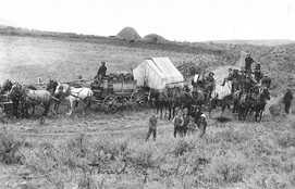
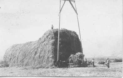
Thrashing Party
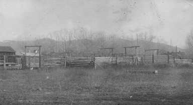
Barrack Ranch
Shenandoah Ranch
1914
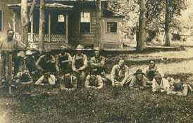
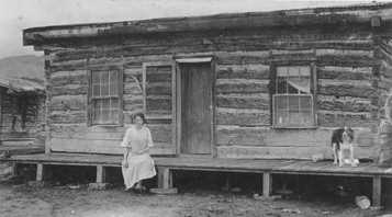
These five photos where contributed by Kim Myers, a past Lemhi County Coordinator. The are from her family collection.
Moore Ranch
Light Ranch
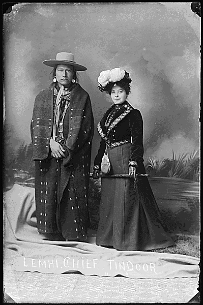
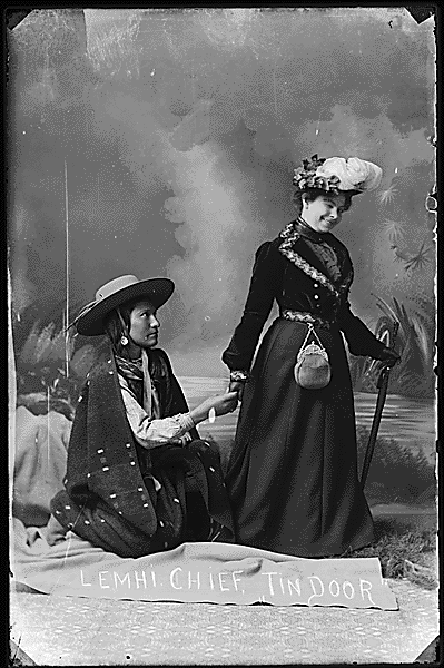
These two photographs have been identified by Joanna Scherer as taken by
Benedicte Wrensted, whose photographic studio was located in Pocatello,
Idaho. Ms. Scherer is an Anthropologist who was working on the
Smithsonian Institution's, Handbook of North American Indians Project.
Wrensted learned photography from her aunt in Denmark in the 1880's and
had a studio in Horsens, Denmark, for about four years. Wrensted came to
the United States from Denmark in 1894, moved to Pocatello, and
purchased the studio of A. B. Hower in 1895. She continued to photograph
members of the local community and Native Americans until 1912, when she
moved to California.
Item from Record Group 75: Records of the
Bureau of Indian Affairs, 1793–1989; Still Picture Records LICON,
Special Media Archives Services Division (NWCS-S), National Archives at
College Park, Maryland
The first white men to come to the Lemhi Valley were the members of the Lewis
and Clark Expedition. On Aug 12, 1805, Captain Meriweather Lewis and three
companions crossed the Continental Divide and reached the headwaters of a creek
that came to be known as Agency Creek, flowing toward the Columbia River Basin.
The explorers were seeking a contact with the Shoshoni Indians in order
to obtain horses to enable the Expedition to cross the mountains. It was a
well-known fact that the Shoshoni Indians had taken horses from the Spaniards in
earlier times. Obtaining the necessary horses was a singular and difficult
problem.
During their winter stay at Fort Mandan, in 1804, the explorers
discovered a young Indian squaw named Sacajawea. Sacajawea, and her husband, the
French trader Charbonneau, joined the expedition, so that she might serve as an
interpreter for the group. As luck would have it, it turned out that Sacajawea's
brother was the Shoshoni chief Cameahwait. This reunion of the two siblings bode
well for the group, and they were granted the horses which they so desperately
sought.
The expedition continued on their way, exploring the Salmon
River for about 70 miles. The made a camp by the creek, called Tower Creek,
because of the rocky towers that surround it. The Salmon River is known as "The
River of No Return" because flatboats that carried freight down the river, could
not back the trip back over the awesome, dangerous rapids.
In 1832, the
first crossing of the Rocky Mountains by wagon was made by Captain B.L.E.
Bonneville, who built a small fort and wintered on the Salmon River near the
mouth of Carmen Creek in 1832.
In 1855, a Mormon missionary colony was
sent from Salt Lake City and settled on the river. A fort was built on the large
open space that the Indians had always used as a pasture for their horses. They
named it Lemhi, which was later to become the name of the Fort, the River, the
Indian Agency and the county. The mission was abandoned in 1858, due to trouble
with the Indians.
Five Montana prospectors, B.F. Sharkey, Elijah Mulkey,
William Smith, Ward Girton and Joseph Rapp, discovered rich gold deposits at a
place about 14 miles west of Salmon, which became "Leesburg" on July 16, 1866.
This discovery of gold on the creek which the Indians called Napias Creek, the
word napias meaning gold or money, started a gold rush that led to a mining town
at Leesburg of 3000 people, the creation of Salmon City in 1867 and the
organization of Lemhi County in 1869.
Miners going to the Leesburg gold
fields were at first ferried across the Salmon River, but soon a toll bridge was
built wide enough for a man or horse. Later this was replaced by a wagon sized
toll bridge.
In 1880, William McKay discovered lead in the dump of a
badger hole on which he had sat down to rest, while hunting stage horses. The
result was a mining boom that created the Viola Mine, one of the richest lead
mines in the world. The town of Nicholia, named for the superintendent of the
mine, had a population of about 3,000 and was one of the largest voting
precincts in Lemhi County in the election of 1886.
The activities of the
Gilmore mines were the incentive for the building of a railroad to Salmon with a
spur to Gilmore for hauling ore to the Oregon Shortline for shipment to the
smelter. The 1929 financial crash caused the Gilmore mines to cease operation.
The Gilmore and Pittsburg Railroad became less useful and stopped its run in
1939. The track was torn up and the scrap metal sold to an agent of the Japanese
government about a year before Pearl Harbor.
Jesse Creek was named for
the pioneer Jesse McCaleb, who was killed by the Indians on Lost River. He was
the partner of George L. Shoup, the last Territorial governor and the first
state governor of Idaho.
The Lemhi County Historical Museum, located at
210 Main St, Salmon, was built by the Historical Society, the Salmon Jaycees,
and the people and friends of Lemhi County, as a memorial to the Pioneers and in
honor of the Idaho Territorial Centennial. It was dedicated on March 4, 1963,
100 years to the day the President Abraham Lincoln signed the bill creating the
Territory of Idaho.
Information for this page was taken from the Salmon
Valley Chamber of Commerce Visitor's Guide, and reprinted with permission.
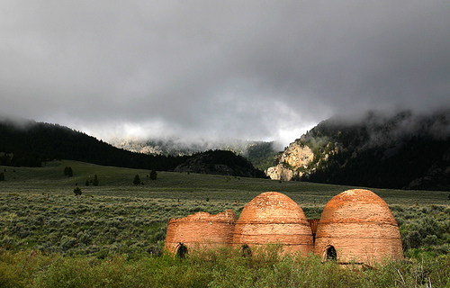
Twelve charcoal kilns were built on the west side of the valley to serve the
mines across the valley at Nicholia. Most of the kilns were dismantled when
mining ceased, but four remain. They are now owned by the U.S. Forest Service,
which has stabilized them and installed interpretive displays.
The kilns
are located off Highway 28 in Lemhi County, 10 miles south of Gilmore Summit.
The kilns were built in 1883 by Warren King of Butte, Montana, and the
materials were made on-site. These kilns fueled the Viola smelter which produced
high grade ore between 1882 and 1885. It was the largest lead producer in Idaho,
outside the Coeur d'Alene valley. The smelter could process 100 tons of ore a
day, but required vast amounts of charcoal. Charcoal was produced here from 1883
to 1889. At that time about 300 immigrants lived on the flat and cut Douglas fir
in the nearby canyons. The logs were hauled to the kilns and bucked into
four-foot lengths. The kilns were loaded through the lower door; when the lower
course was completed, an opening was made in the dome and the loading proceeded.
Once the kiln was full, tinder in the base was ignited, the doors were sealed,
and the draft vents in the base were carefully regulated. The slow burning
reduced the wood to charcoal.
The kilnmaster watched the color of the
smoke to tell when the wood had been reduced to charcoal. Volatile gasses
sometimes blew the top off the kiln. There were sixteen kilns here at one time,
but the bricks were salvaged by settlers. It is estimated the ovens burned
150,000 cords of wood in seven years. When the Viola closed, forty acres of
cordwood were stacked on the bench behind the kilns, and the owner could not
even give it away. Lead poisoning was a serious problem at the smelter. It
killed men who worked in the plant as well as the area's pets and livestock.
The kilns are twenty feet high and twenty feet in diameter; their capacity
was approximately thirty-five cords. As the moisture, noncombustible gases and
tars were distilled, the wood was reduced to carbon with one-half its former
volume and one-quarter of its weight. A cord of wood yielded about 500 pounds of
charcoal. It took a week to load, fire, and unload a kiln. Wagons then carried
the "coal" to the smelter across the valley.
AUTOS CRASH, KILL 6, INJURE 3 IDAHOANS
Salmon, Idaho, March 30 -- A Sunday drive for elderly patients of a Salmon
convalescent home turned into tragedy when six persons were killed and three
critically injured in a grinding head-on collision eight miles north of here on
U.S. Highway 93.
The dead included William SILBAUGH, 74, operator of
Silbaugh's Convalescent Home, and three of his patients. A Salmon woman and
her 12-year-old son were killed in the other car. The dead in addition to Mr.
SILBAUGH were identified as: Gertrude COCKRELL, 72, Alice KIRTLEY, 70, Joseph
TROWBRIDGE, 70, all patients at the nursing home. MRS. Cecelia WALCHLI, 31,
and her son, Raymond, 12.
The injured were listed as:
Flora CASSELL, 65, a passenger in the Silbaugh auto, head injuries and fractures of both arms and legs.
Vickie Lynn WALCHLI, 6, daughter of Mrs. WALCHLI, multiple fractures of the left arm.
Her brother, Kirk, 4, brain concussion and facial lacerations.
The injured were taken to Steele Memorial Hospital in Salmon, where their conditions
were listed as "critical." Idaho State Patrol Trooper Jim Perkins said the
accident occurred at 2:40 p.m. He said evidence showed one of the cars was on
the wrong side of the highway. An inquest will be conducted by Lemhi County
Coroner Delbert Jones, probably Tuesday or Wednesday, the trooper said.
Mr. SILBAUGH was operating the southbound auto, apparently taking some of his
patients out for a Sunday drive, the officer said. Mrs. WALCHLI was the driver
of the northbound vehicle.
Trooper Perkins said the SILBAUGH car, a 1955
sedan, proceeded south on U.S. 93 after the impact for 45 feet and came to rest
on its top on the west side of the highway. The WALCHLI auto, a 1951 sedan, was
knocked backward 15 feet from point of impact and came to rest on the east
shoulder. Both autos were demolished.
Trooper Perkins said there was a
slight curve at the point of collision.
When officers arrived, five
injured had expired, and MRS. WALCHLI died before she could be removed from her
car.
The dead and injured were removed to Salmon by the Jones Funeral
Home ambulances. Lemhi County Sheriff's Deputy Cliff Helpher assisted in the
investigation. Mrs. WALCHLI was the wife of Sherman WALCHLI, of Salmon.
Contributed 21 Feb 2010 by Stu Beitler
Source: Salt Lake City Tribune, Utah, 1958 Mar 31
In April 07, 1856 Joseph Harker was set apart
by Parley P. Pratt for a mission at Fort Lemhi, in Idaho, leaving behind him two
wives and twelves children, with 100 lbs of bread stuff to keep them until he
returned from his mission. Joseph left Salt Lake City for Fort Lemhi April 14th.
April 16 while in Ogden City he traded his team of horses for a yoke of oxen and
a cow.
On Joseph's trip to Fort Lemhi he camped at the following places,
camped at William Mewers, Bear Mill, Ogden City, Bingham Fort, Brigham City,
Stopped at Lewis Whites, Bear River, Malad Springs, camped at head of Malad
Valley, camped at the head of Malad Waters, Banac [Bannack ?]Creek, Banac Creek
again, Parssnif[?] River, [Portneuf River in Pocatello?] Snake River, crossing
the Snake River wagon box turned over in the river and they camped on a sand bar
in the middle of the Snake, crossing the Snake River, crossed the Snake River in
the afternoon, camped on the Snake River, camped on the Snake again, and camped
again on the Snake, Madison Legg, Mud Lake, Spring Creek, Spring Creek again,
camped on Millers Creek, next four nights camped on Salmon River, Arrived at
Fort Lemhi the following day.
June 01, 1856, the grasshoppers came and
destroyed most of their crops, June 15, replanted wheat. June 30 heavy frost cut
corn and vines down. Digging mill seats for grit mill.
July 16, "I am
sick today, I have lived mostly on boiled corn for four weeks and at work I am
so weak and I have spit blood for some days, I have nothing to eat but a bit of
butter-milk cheese". July 18, I was sick in bed all day, at noon I had a biscuit
sent me and a cup of tea. July 28th frost on the bottoms cut the vines and
potatoes. After harvesting the wheat doing the fall plowing.
October 16,
1856 Joseph Harker and three other missionaries left Fort Lemhi to return to
Salt Lake for the winter. October 24, met company going to Fort Lemhi, received
2 letters from my family, they was without shoes and one child was dead.
November 04, arrived home at 1 o'clock a.m.
Second year at Fort Lemhi
March 20, 1857, I loaded my wagon and sent it to Salt Lake City, to be ready
to start in the morning on my mission to Salmon River, in the evening I went
meeting, several of the Brethren volunteered to put up my crops.
March
31, 1857 traveled 4 miles and camped in canyon, snowed from 6" to 2 1/2 feet of
snow, "we ascended the mountain by putting ten yoke of oxen on the first wagon".
April 1857 Apr 01, traveled 5 miles and crossed the divide and camped on
Banack Creek, cattle went back ten miles during the night. April 14, we traveled
24 miles and camped on Spring Creek, we had no feed nor water through the day
and some of our cattle gave out. April 17, four men started for Fort Lemhi for
help. April 19, we traveled 13 miles, ten yoke of oxen arrived after dark. April
22 traveled 14 miles and camped in Fort Lemhi.
April 25, we organized a
guard to guard the fort. May 08, this morning we had five inches of snow on the
ground, President Young and company arrived from Salt Lake Valley, along with
Kimble, Hyde, Snow, and F.D. Richards they gave counsel to bring our families
and marry the squaws.
May 13, President Young and company left for home.
Blessed the Saints.
May 17 I was at meeting, Brother Smith said the
Brethren had got to bring their families. May 23, I was making ox yokes. In the
evening we drew lots for our farms that had been laid out. May 25 commenced
cutting logs to build a log cabin. June 01, I was watering the garden. I am lame
in my arm and commenced to write a history of my life. June 04, I was at fast
meeting. It was reported that Indian Thos killed by the Indians. June 10, Eight
of us started to the mountains, to hunt a silver mine, traveled 25 miles. Jun
16, I was hauling House logs. The Indians met together today to make a treaty of
peace with each other. June 18, I was building my house. This morning a company
left here to fetch their families. June 23 it is reported that there is five
hundred Black Feet Indians in these mountains waiting to kill off the Banacks
Indians. July putting roof on cabin and hauling rock for chimney. Mowing and
hauling hay, cleaning and salting fish. August, cutting and thrashing wheat, we
raised about 4000 bushels of wheat. September 19, John Priest has made 5 quarts
of molasses, the first made in Fort Lemhi. Went bear hunting, shot a yearling
bear four times. September 26, Black Feet Indians stole my horse and 21 more
horses, from the Fort.
October 16, two of the Brethren left here for
Salt Lake so to meet the Company. The Indians is getting (sa) [savage?] and
predict our fort will be burned up.
Unknown to Joseph on October 19th
his son Joshua from his second wife died in Taylorsville, this was his second
child to die while he was on his mission at Fort Lemhi, the first to die was Ann
E. Harker, which died just a year before, just as he was coming home for the
winter, The two children that died were brother and sister to Eliza Ann Harker,
children from Joseph's 2nd wife.
An Indian brought word that the
soldiers were coming to Salt Lake Valley. October 20, our Captain of the fort
Bro. Smith came in from Salt Lake, he brought the news that President Young has
declared our independence.
October 27, 1857, Two Hundred men entered
Fort Lemhi that had been sent from Salt Lake City to bring the settlers in the
Salmon River Mission back. October 28, in the afternoon we left Fort Lemhi for
Salt Lake City, we traveled 7 miles. Fort Lemhi was abandoned; all their labor
and effort were for naught. This was due to the fact that 2500 soldiers were
marching on Salt Lake City.
From the book Illustrated Stories from
Church History published by Promised Land Publications, volume 15, page 18,
reads: "In the emergency the Church Leaders felt the necessity of calling home
all of the apostles and missionaries and certain of the Saints on Settlement
missions. Elders Amasa Lyman and Charles C. Rich were instructed to break up the
San Bernardino [California} settlement and bring the people back to Utah.
Similarly Elder Orson Hyde, in charge of the Carson Valley Saints, was to see
that those Saints returned to aid in the defense. Before leaving southern
California, the San Bernardino Saints purchased a large supply of weapons and
ammunition.
Contributed by Rod E. Meyers
Salmon is home to the oldest remaining chapter of the OES in the state of Idaho. Although it was the second chapter to be organized in the state, the first chapter, in Mount Idaho, did not last very long before it was disbanded.
Salmon's chapter, the Hugh Duncan No. 2, was chartered March 18, 1886, and the Reverend Hugh Duncan was authorized to institute the chapter. Rev. Duncan, a native of Scotland, was a resident of Sheridan Montana, who came to preach once a month to the people of Salmon. He was a past Grand Master of the Grand Lodge A.F. and A.M. of Montana and was the driving force in the creation of this chapter. In honor of the man who worked so hard to get the chapter started, the charter members voted to name it after him.
The first officers elected to serve the chapter were
Anna B McCaleb
Emma Wentz
Emma J White
Barbara McNicoll
Ada J Merritt
Margaret R Hornbeck
Ellen F Beattie
Clara M Mintzer
Anna B Sharkey
Anna Stevens
James L Kirtley
George G Wentz
Montaville White
Robert McNicoll
Anthony Hornbeck
James Beattie
Olin Mintzer
Frank B Sharkey
Isaac Stevens
Josiah C Chase
W. H. Porter
Peter Van Norden
The chapter held its meetings for many years in the upper story of a log building in Salmon. Later as the chapter grew more prosperous and the Masons moved to larger quarters, the chapter naturally followed. The meetings were moved to the third floor of the Pioneer Mercantile building which was owned by and housed the mercantile business of George L. Shoup, the first governor of Idaho. The first story was expressly built by Mr. Shoup for the Masonic Lodge and OES meetings and was richly furnished by him and given to the Masons as a gift. The lodge held there meetings in this location for many years, until they purchased the property just across the street from it, and had it remodeled for their needs. There they were housed on the second floor, until the building burned down in 1931. They lost all their records in the fire, but managed to salvage the brick walls, which then went into building their one story building, which they were still occupying in 1961, at the time this article was written.
The chapter has had a rich and proud history over the past 111 years, and more information about it can be obtained by contacting: Order of the Eastern Star, Hugh Duncan No. 2 Chapter, 207 W. 4th St, Salmon Idaho, 83467
Information was obtained from the Diamond Jubilee Edition of the Recorder-Herald newspaper, dated 1961, and used with permission.
Copyright © 1996- The USGenWeb® Project, IDGenWeb, Lemhi County

This page was last updated
08/20/2025